Provider: EC - HORIZONT 2020
Another participant in the project: Ústav výzkumu globální změny AV ČR, v. v. i.
Keywords: xxx
Annotation of project:
xxx
Click for the search
Number of projects found: 314
Methods of intensification of organic farming on arable land
Provider: Ministerstvo zemědělství
Coordinating recipient: Mendelova univerzita v Brně
Another participant in the project: Ústav výzkumu globální změny AV ČR, v. v. i.
Keywords: Biological control; crop rotation; organic agriculture; plant-growth promotion, soil biodiversity
Annotation of project:
The aim of the project is to propose methods of organic farming on arable land, which will lead to the intensification of crop production while fully respecting the rules limiting production in terms of the environment and consumer health, by applying an integrated approach using the synergistic effect of agronomic, biological and mechanical/physical methods of crop protection and management. The steps implemented during the project will be focused on the use of the latest knowledge and practical experience with the intensification of organic farming in our country and other European countries with developed organic farming, especially in Austria.. The project will also use knowledge from the biology of harmful organisms and prepare appropriate plant protection systems in organic farming.
Evaluation of the impact of land cover changes on local hydrology and climate in the Krkonoše National Park using remote sensing and hydrological modeling
Provider: Technologická agentura ČR
Another participant in the project: Ústav výzkumu globální změny AV ČR, v. v. i.
Keywords: land cover; forest; hydrology; modelling; remote sensing
Annotation of project:
1. Analyze long-term development of land cover (since the 1980s) with emphasis on changes in forest and on the current state of forest health in the upper Úpa and Horní Čistá river basins using various types of remote sensing (RS) data. 2. Analyze long-term time series of hydrological and hydrometeorological data and describe the development of climate and hydrology of the monitored area since the 1940s. 3. Using hydrological modeling and inputs generated under objectives 1 and 2 to simulate the long-term impact of land cover changes (LCC) on the local climate and hydrology. 4. Design a methodology for monitoring the impact of LCC on local hydrology using RS and hydrological modeling. 5. Design an Application for automated RS data processing and evaluation of hydrological conditions.
Evaluation of hazard-mitigating hybrid infrastructure under climate change scenarios
Provider: Grantová agentura České republiky
Coordinating recipient: Univerzita Jana Evangelisty Purkyně v Ústí nad Labem
Another participant in the project: Ústav výzkumu globální změny AV ČR, v. v. i.
Keywords: Floods;landslides;soil erosion;climate change;climate change adaptation;hybrid infrastructure
Annotation of project:
The project will critically evaluate hybrid infrastructure that can be used for climate change adaptation as an alternative to the grey and green measures, especially in post-socialist countries, such as Slovenia and Czechia. In the literature, hybrid measures have been overshadowed by grey and green measures, which, however, often showed to be ineffective, especially for extreme events as predicted by climate change scenarios, or their implementation is limited by space in densely populated areas. Moreover, in some countries such measures are not common in planning or encounter various types of disapproval. Floods, soil erosion, landslides and compound events will be researched, which will enable us to identify measures that mitigate multiple hazards. The effects of hybrid infrastructure on risk reduction will be evaluated using environmental modelling under conditions of climate change scenarios. Along, the new documentation and standardization of hybrid infrastructure will provide a comparative framework for their further international evaluation and implementation.
Development of the methodology for monitoring and assessing the hydromorphological characteristics of watercourses
Provider: Technologická agentura ČR
Coordinating recipient: Ústav výzkumu globální změny AV ČR, v. v. i.
Another participant in the project: Výzkumný ústav vodohospodářský T. G. Masaryka, v.v.i.
Another participant in the project / Organizational Unit guaranteeing Solutions: Univerzita Palackého v Olomouci
Keywords: hydromorphology; ecological status; EU WFD; hydromorphological assessment
Annotation of project:
The project proposal responds to the long-standing unsatisfactory situation in the field of monitoring and assessment of hydromorphological characteristics of watercourses in the Czech Republic, as a part of the assessment of the ecological status of water bodies required by the WFD 2000/60/ EC. The main objective of the project is to develop a new methodological procedure and software for a comprehensive assessment of the hydromorphological status of surface water bodies, based on a combination of distance and field survey data, respect the requirements of European Commission and be user-friendly in terms of time and fieldwork effort. The selection of individual hydromorphological parameters and indicators used will consider their importance for the relevant biological components.
Importance and protection of floodplains as an environment for the fulfillment of the landscape ecostabilisation function
Provider: Technologická agentura ČR
Coordinating recipient: Ústav výzkumu globální změny AV ČR, v. v. i.
Another participant in the project: Masarykova Univerzita
Keywords: floodplain; ecosystem function; ecosystem service; human impact; ecological stability; land-use; environmental change
Annotation of project:
This project proposal aims to create a comprehensive methodological approach for determining the level of floodplain disruption in current conditions, based on identification and evaluation of the key ecosystem functions and services, provided by the floodplains. On the basis of this procedure, it will be possible to set certain limit values for selected significant ecostabilization functions, the exceeding of which may result in impairment of the performance of these functions. The procedure will take into account current and anticipated natural conditions and varying degrees of anthropogenic pressure. The project's results will contribute to ensuring a balance between the use of floodplains and the conditions necessary to ensure the performance of a number of important functions.
ExtremeAdapt – nondestructive monitoring of biomolecular response of desert extremophiles to the polyextreme environment
Provider: Grantová agentura České republiky
Recipient: Ústav výzkumu globální změny AV ČR, v. v. i.
Keywords: Raman spectroscopy;imaging;global change;molecular adaptation
Annotation of project:
Yet unexplored geobiological specimens from the Atacama Desert will be studied, representing polyextreme environment, where aridity meets high doses of UV+PAR irradiation. The environment thus represents an unique natural laboratory. The crucial aspect of the project will be nondestructive "in-situ" investigation of biomolecules synthesized by these organisms. Raman spectroscopy with emphasis on Raman imaging will be a key method applied together with advanced microscopy to study spatial distribution of UV+PAR protective microbial pigments and the other biomolecules. It is essential to explain resistance strategies of endoliths in the harsh environment. The following material will be studied: a) different rock from the same polyextreme environment, b) the same rock and different microclimates and c) the same rock and same polyextreme environment but different microhabitat (i.e., chasmo-, crypto- and hypoendolithic habitats).
C3Surf2 - Access to high-resolution gridded datasets over Europe based on in situ observations
Provider: European Centre for Medium-Range Weather Forecasts
Another participant in the project: Ústav výzkumu globální změny AV ČR, v. v. i.
Keywords: meteorology, in-situ observations, copernicus, services
Annotation of project:
The service established in contract C3S_311a Lot4 during the first phase of the Copernicus programme is consolidated and further expanded in this proposal. The established operational service now delivers regularly updated gridded products based on European in-situ data for a set of Essential Climate Variables (ECVs). To serve climate change monitoring and climate impact assessments a large number of user-oriented climate indices, based on the gridded data products, are provided. Based on these dataset, statements on the European climate are routinely made or input is provided to such statements.
PAUL (Pilot Application in Urban Landscapes - Towards integrated city observatories for greenhouse gases)
Provider: EC - HORIZONT 2020
Another participant in the project: Ústav výzkumu globální změny AV ČR, v. v. i.
Keywords: xxx
Annotation of project:
The ?Pilot Application in Urban Landscapes ? towards integrated city observatories for greenhouse gases? (PAUL) project supports the European Green Deal by creating capabilities to observe and verify greenhouse gas emissions from densely populated urban areas across Europe. Cities are recognized as important anthropogenic greenhouse gas emission hotspots and therefore play a significant role in any emission reduction efforts. The PAUL project aims to increase our understanding of specific needs of greenhouse gas emission assessment in urban environment; it compares available and novel observational approaches and implements an integrated concept for a city observatory, providing unique data sets that feed diverse modelling approaches, scientific studies and will be the base of services towards the city administrations. A specifically innovative approach is the co-design of services, models and observations between city administrators and scientists from multiple disciplines including social and governmental sciences.The PAUL co-design approach will exploring the needs of the cities and combining these with the scientific outcomes. This allows to introduce smart services to the cities, supporting evidence-based decisions on climate action and strategic investments. Overarching goals of PAUL are to: 1) implement elements of a pilot city observatory in a large (Paris), a medium (Munich) and a small (Zurich) European city, 2) collaborate with city stakeholders and engage citizens in co-designing services that are required for GHG monitoring in order to validate the implementation of Paris Agreement, and 3) increase our understanding of specific needs of GHG assessment in urban environment and create a service portfolio for setting up an urban greenhouse gas observatory.
Physiological, morphological and growth response of fir and beech along the geographical gradient – basis for predicting future development trends
Provider: Grantová agentura České republiky
Coordinating recipient: Výzkumný ústav Silva Taroucy pro krajinu a okrasné zahradnictví, v.v.i. (dále jen "VÚKOZ, v.v.i.")
Another participant in the project: Mendelova univerzita v Brně
Another participant in the project: Ústav výzkumu globální změny AV ČR, v. v. i.
Keywords: European beech;silver fir;Carpathians;regeneration;growth;latitudinal gradient;climate change; prediction
Annotation of project:
European forests are facing enormous threats from rapid global climate change affecting recent and future performance of tree species. In this proposal we focus on European beech and silver fir the two important tree species for big part of European forests of middle and higher elevations. Carpathians serve as a model site comprising sufficient geographical and climatic gradient. Apart from physiological and morphological traits, which will be paralleled with climate and radial growth, in addition growth responses will be paralleled with different indexes obtained from satellite images along the studied geographical gradient. Measured parameters coupled with climatic data will be used to develop realistic response-model for both species and provide future response scenarios with novel, sophisticated machine learning algorithms. To truly understand the combined effects of different factors we are about to use multidisciplinary approach including ecophysiological and morphological observations, dendroclimatology, wood anatomy and carbon isotopes analysis, remote sensing and modelling.
Strategie AV21

News
The Clim4Cast forecasting tool was presented at the EGU General Assembly 2026 in Vienna by Lukáš Dolák. The original contribution was also chosen to be presented at a press conference for journalists, along with 17 other contributions out of a total of 20,000. Within the Press conference (https://www.egu.eu/gamedia/2026/press-conferences/#PC1), the most outstanding Clim4Cast outputs were introduced, including the forecasting tool. The attending journalists appreciated both the web platform and the tool. We honestly hope that this event contributed to spreading the word not only among journalists but also to the wider public and researchers.
More 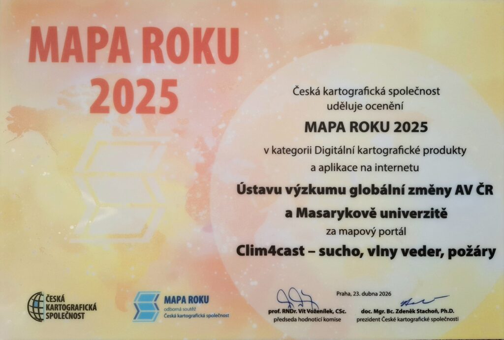
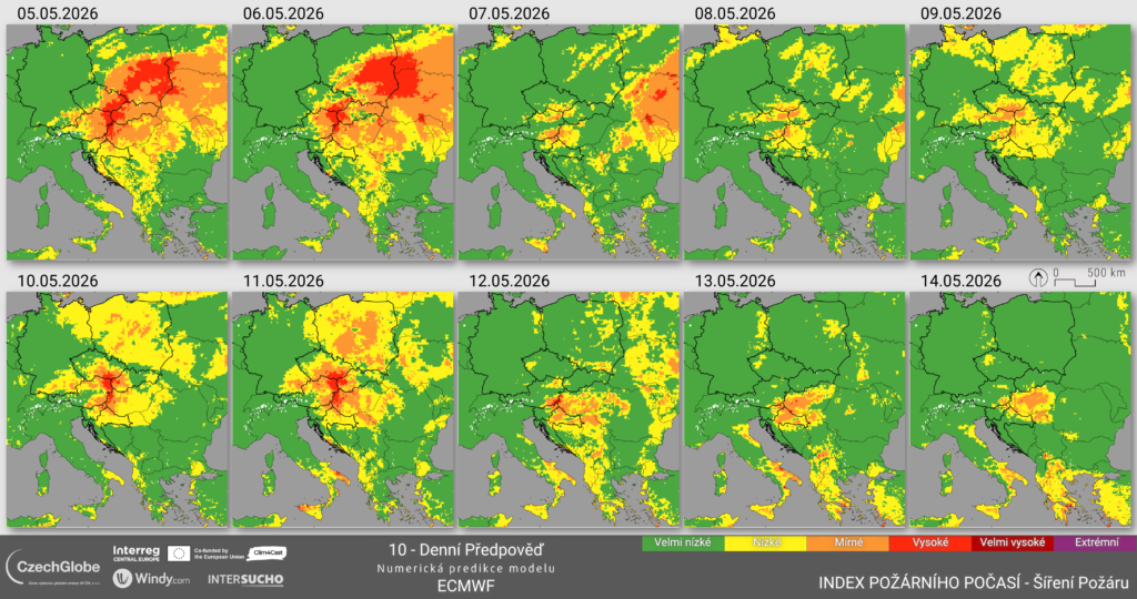
The expert jury of the Czech Cartographic Society has announced the results of the prestigious Map of the Year 2025 competition across six categories. The Clim4Cast project team, from the Global Change Research Institute CAS and Masaryk University, also participated. In the category Digital Cartographic Products and Online Applications, the team received an award among 14 competing entries for the Clim4Cast map portal – drought, heatwaves, wildfires.
More 
3 May 1943 – 1 February 2026
With deep sorrow, we announce that on 1 February 2026, Sune Linder, Emeritus Professor at the Swedish University of Agricultural Sciences in Uppsala and at the Southern Swedish Forest Research Centre in Alnarp (Sweden), passed away.
More 
ICOS Science Conference, organised every second year by the ICOS community, is a global event open to scientists and other experts working in greenhouse gases and biogeochemical cycles. ICOS Science Conference 2026 will be organised on 15-17 September 2026 in Lund, Sweden and online. The themes reflect ICOS’s three domains – Atmosphere, Ecosystem and Ocean – and incorporate broader themes such as climate services, science communication and cooperation between Research Infrastructures.
The abstract submission deadline is 6th March 2026, 15:00 CET. More here
More 
We are excited to announce that registration is now open for the 2nd International AnaEE Science Conference (ANAEESC26), the flagship biennial event of AnaEE-ERIC (Analysis and Experimentation on Ecosystems), Europe’s largest network for experimental ecology and climate change research. Taking place September 29 – October 1, 2026, at the Palais de l’Europe in Menton, France, this essential gathering brings together leading researchers and policymakers to address critical challenges facing global ecosystems through seven scientific sessions, featuring distinguished keynote speakers including Prof. Marie-Hélène Jeuffroy – INRAE, Prof. Bart Muys – KU Leuven and Dr. Nathalie Hilmi – The Scientific Centre of Monaco.
We strongly encourage you to submit abstracts for oral and poster presentations. Early career researchers can compete for our inaugural Environmental Rising Star Award, which includes up to €2000 for a research visit to an AnaEE facility abroad. The conference also features workshops on Open Science practices, policy dialogues, and valuable networking opportunities. Visit anaee.eu to register and submit your abstract.
Events / Projects / Research


We stand for Ukraine
