Provider: Grantová agentura České republiky
Recipient: Ústav výzkumu globální změny AV ČR, v. v. i.
Keywords: Atmospheric circulation;meteorological observations;reanalyses;climate models;climate change; Central Europe
Annotation of project:
The project concentrates on an extensive validation process of state-of-the-art climate models
and downscaling methods based on various reference datasets of climate observations, to
identify their strong and weak points and then apply the gained knowledge to improve the
reliability of climate projections in Central Europe (represented here by Poland, Czech Republic,
part of Slovakia and eastern Germany). A special attention will be paid to atmospheric
circulation (as the main weather driving factor) with an emphasis on its representation in climate
models. Occurrence of different circulation types and their intensity is important for the origin of
significant weather events and extremes. Therefore, the detailed knowledge concerning the
ability of climate models to assess impacts of atmospheric circulation and its long-term trends
will be a key to better understand and interpret future climate projections.
Click for the search
Number of projects found: 314
Critical study on ground based vs tall tower aerosol measurements: effect of boundary layer
Provider: Grantová agentura České republiky
Coordinating recipient: Ústav chemických procesů AV ČR, v. v. i.
Another participant in the project: Ústav výzkumu globální změny AV ČR, v. v. i.
Keywords: atmospheric aerosol;vertical profile;atmospheric boundary layer;aerosol radiative forcing; nucleation;nanoclusters;chemical composition
Annotation of project:
Main goal of the project is to describe the relationship between planetary boundary layer (PBL) height and atmospheric aerosol (AA) in vertical profile. The project plans to use a unique infrastructure including 250 m tall tower at a Central European rural background site. Chemical and physical properties of AA will be measured by state-of-the-art aerosol instrumentation at two different heights (ground and 230 m) with high-time resolution, depending on daily and seasonal cycles of PBL height, chemical composition and changes in physical parameters of AA alongside radiative forcing and the concentration of AA nanoclusters. This will provide crucial knowledge of the changes of atmospheric properties within and above PBL and thus help to reduce the current uncertainties in atmospheric aerosol forcing of the Earth's climate system. Furthermore, it will provide important insights into the representativeness of conventional ground-based measurements of AA properties, which may lead to their re-evaluation in relation to vertical measurements and in combination with satellite measurements.
The role of coherent structures in the turbulent energy transport and energy balance non-closure
Provider: Grantová agentura České republiky
Recipient: Ústav výzkumu globální změny AV ČR, v. v. i.
Keywords: coherent structures;eddy covariance;flux variance;latent heat flux;sensible heat flux;surface renewal
Annotation of project:
The knowledge of the turbulent energy (latent and sensible heat) fluxes is critical in research fields such as meteorology, hydrology and ecophysiology. Eddy covariance (EC) is widely used technique for their measurements, however, a recalcitrant problem is so called energy balance non-closure representing on average 15% across more than 900 sites worldwide. Alternative methods for energy fluxes determination are e.g. flux variance (FV) and surface renewal (SR). We aim to revise the FV and SR methods in a single framework emphasizing a clear physical interpretation of all methodological aspects. Following previous studies documenting better, yet unexplained, energy balance closure of SR as compared to EC, we aim to analyze the physical causes of this phenomena. In line with the most recent studies indicating the important role of large eddies in the EC non-closure problem, we suggest that studying energy balance closure within the frame of FV and SR methods that relies largely on large coherent eddies can provide further links in this still not fully understood research topic.
COPERNICUS HYPERSPECTRAL IMAGING MISSION FOR THE ENVIRONMENT (CHIME) L2 ALGORITHM AND PROCESSOR PROTOTYPING AND DEVELOPMENT
Provider: European Space Agency
Recipient: Ústav výzkumu globální změny AV ČR, v. v. i.
Keywords: xxx
Annotation of project:
xxx
Recipient: Ústav výzkumu globální změny AV ČR, v. v. i.
Keywords: xxx
Annotation of project:
xxx
CAIRTEX
Provider: European Space Agency
Recipient: Ústav výzkumu globální změny AV ČR, v. v. i.
Keywords: xxx
Annotation of project:
xxx
Recipient: Ústav výzkumu globální změny AV ČR, v. v. i.
Keywords: xxx
Annotation of project:
xxx
Science-based background data for the restoration of marginalised mountain areas in the Czech Republic
Provider: Ministerstvo školství mládeže a tělovýchovy
Recipient: Ústav výzkumu globální změny AV ČR, v. v. i.
Keywords: Marginalised mountain areas, Environmentally Sensitive Area Index, Landscape ecological stabiity, Cataloque of restoration measures
Annotation of project:
The main activities of the project will be the modification of the prepared methodology for the assessment of the Environmentally Sensitive Area Index (ESAI), formation of a set of indicators of environmental parameters of ecological stability and preparation of a list of adaptation measures that improve the conditions for maintaining or supporting the sustainable use of natural resources. A practical outcome of the project will be the c reation of an interactive specialized map for user-friendly application by stakeholders.
Greenhouse gas flux dynamics in forest ecosystems and the effects of drought episodes, elevated atmospheric CO2 concentration, and nitrogen deposition
Provider: Ministerstvo školství mládeže a tělovýchovy
Recipient: Ústav výzkumu globální změny AV ČR, v. v. i.
Keywords: Methane, CH4, nitrous oxide, N2O, carbon dioxide, CO2, greenhouse gas fluxes, physiology of forest trees, forest ecosystem, nitrogen deposition, drought, elevated CO2 concentration, climate change, multifactorial manipulation experiments
Annotation of project:
We aim i)to reveal emission potentials of CH4 and N2O for various European tree species of temperate zone, ii) to study the effect of environmental parameters (e.g., reduced water availability, elevated CO2 concentration and N deposition) and their interactions on CH4 and N2O fluxes from soils and trees, and iii) to quantify losses of C and N from soils and trees in form of gaseous CH4 and N2O under the effect of N deposition and soil water availability.
Three-dimensional forest ecosystem monitoring and better understanding by terrestrial-based technologies (3DForEcoTech)
Provider: Ministerstvo školství mládeže a tělovýchovy
Coordinating recipient: Ústav výzkumu globální změny AV ČR, v. v. i.
Keywords: Airborne laser scanning; unmanned laser scanning; terrestrial laser scanning; radiative transfer model; DART; 3D tree reconstruction; quantitative structure model; forest characteristics; mechanical stability; above ground biomass; growing stock
Annotation of project:
Ecological stability (resistance and resilience) of a forest stand against various disturbances and stress factors is partially dependent on canopy structure, which reflects species and age variability in the canopy. Characteristics such as height, crown shape, and above ground biomass (AGB) can be derived from field measurements. These are often time and manpower consuming and thus clearly time and spatially limited, whereas methods using unmanned and airborne laser scanning (ULS and ALS) allow mapping large areas repeatedly. Though, even those methods rely on field data, which are used for calibration of regression models and for their independent validation. In this project, we therefore introduce an approach replacing field data by virtual 3D forest stands. Terrestrial laser scanning data will be used to construct realistic 3D tree representations of common species (spruce, pine, beech, oak). From these virtual forest stands with a large structural variability will be compiled, on which laser scanning data will be simulated by RTM. The simulated data will be used to derive a reliable individual tree detection algorithm from ULS, to improve an ABA method for forest characteristics retrieval from ALS, and to introduce advanced methods to assess tree/stand mechanical stability. Activities of the project are closely related to already running COST action 3DForEcoTech (CA20118), which aims to support research of forest ecology by using modern and constantly developing 3D laser scanning methods and bring them closer to forestry practice.
ENVision
Provider: Masarykova univerzita
Recipient: Ústav výzkumu globální změny AV ČR, v. v. i.
Keywords: xxx
Annotation of project:
Remote sensing data – obtained from satellite or airborne imagery – play an essential role in many applications, especially in the timely assessment of the state of a landscape. CESNET organization provides a data warehouse (national point) of Sentinel satellite data for the Czech Republic and a visualization portal providing basic capabilities for their elementary analysis. This project aims to develop a comprehensive data-analytical solution ENVision, which will provide a modularly extensible and scalable platform for advanced analysis of such satellite data. For local refinement of global analyses or locally specific analytical methods, the platform will also provide the possibility to import locally acquired airborne or drone da-ta, which are acquired and managed by, among others, the Institute of Global Change Re-search Institute of the Czech Academy of Sciences (CzechGlobe). In addition to integrating previously developed prototypes of analytical methods that process and analyze remote sens-ing data, the project will also test the potential of machine learning and artificial intelligence techniques to refine these previously used analytical methods for assessing the state of forest ecosystems based on satellite data.
AdAgriF - Advanced methods of greenhouse gases emission reduction and sequestration in agriculture and forest landscape for climate change mitigation
Provider: Ministerstvo školství mládeže a tělovýchovy
Coordinating recipient: Ústav výzkumu globální změny AV ČR, v. v. i.
Another participant in the project: Mikrobiologický ústav AV ČR, v. v. i.
Another participant in the project: Česká zemědělská univerzita v Praze
Keywords: Sustainable agriculture, sustainable forestry, carbon farming, regenerative farming, agrosystems, climate change impacts, climate change adaptation, climate change mitigation, greenhouse gases, CO2, CH4, N2O, crops, forests, soil, stable carbon, plant root exudates, flexible agronomy and forestry management practices, remote sensing, land surface modelling, inverse modelling, crop growth models, agrosystem and forestry systems models, flexible management in agronomy and forestry, ecosystem, landscape, region, sustainability, environmental risks, holistic approach, socioeconomic scenarios, participation, leverage points, science-policy-practice interface, ESFRI research infrastructures, training, capacity building
Annotation of project:
International AdAgriF scientific team aims to turn agriculture and forestry into long-term sinks and stocks of carbon and prevent avoidable emissions of CO2, N2O, and CH4. This will be achieved by greatly modernized infrastructure and three transdisciplinary research WPs spanning from molecules to landscape and society. The research will be imbedded in extensive network of excellent collaborating institutes fostering the growth of all participating scientists and reducing the research risk.
Strategie AV21

News
The Clim4Cast forecasting tool was presented at the EGU General Assembly 2026 in Vienna by Lukáš Dolák. The original contribution was also chosen to be presented at a press conference for journalists, along with 17 other contributions out of a total of 20,000. Within the Press conference (https://www.egu.eu/gamedia/2026/press-conferences/#PC1), the most outstanding Clim4Cast outputs were introduced, including the forecasting tool. The attending journalists appreciated both the web platform and the tool. We honestly hope that this event contributed to spreading the word not only among journalists but also to the wider public and researchers.
More 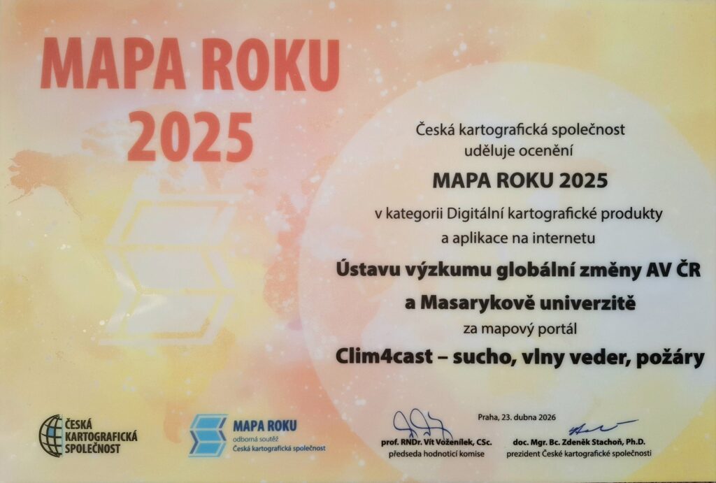
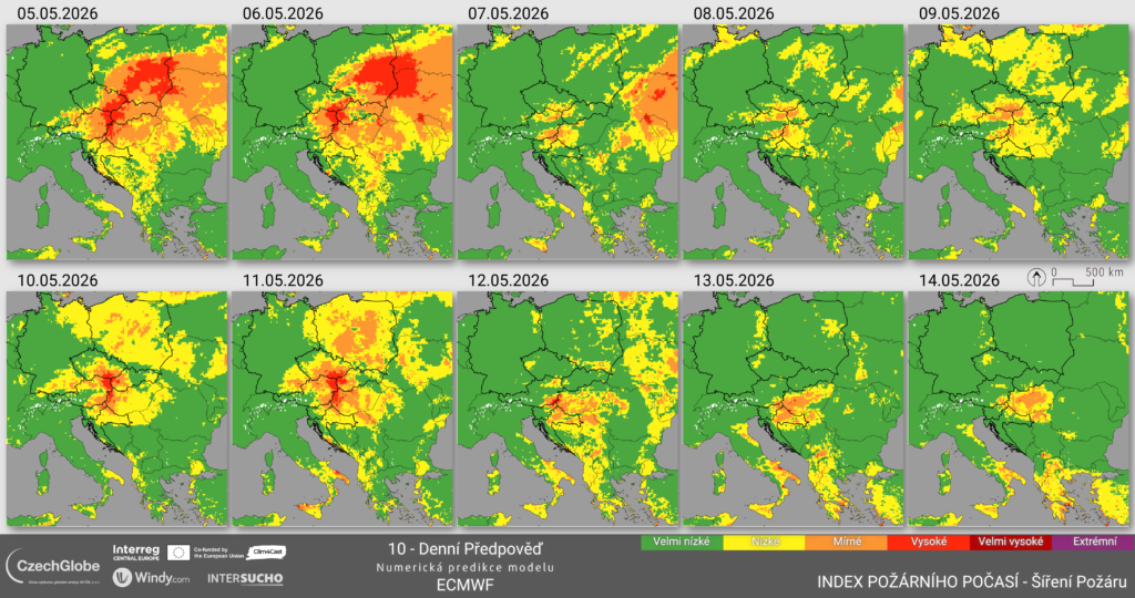
The expert jury of the Czech Cartographic Society has announced the results of the prestigious Map of the Year 2025 competition across six categories. The Clim4Cast project team, from the Global Change Research Institute CAS and Masaryk University, also participated. In the category Digital Cartographic Products and Online Applications, the team received an award among 14 competing entries for the Clim4Cast map portal – drought, heatwaves, wildfires.
More 
3 May 1943 – 1 February 2026
With deep sorrow, we announce that on 1 February 2026, Sune Linder, Emeritus Professor at the Swedish University of Agricultural Sciences in Uppsala and at the Southern Swedish Forest Research Centre in Alnarp (Sweden), passed away.
More 
ICOS Science Conference, organised every second year by the ICOS community, is a global event open to scientists and other experts working in greenhouse gases and biogeochemical cycles. ICOS Science Conference 2026 will be organised on 15-17 September 2026 in Lund, Sweden and online. The themes reflect ICOS’s three domains – Atmosphere, Ecosystem and Ocean – and incorporate broader themes such as climate services, science communication and cooperation between Research Infrastructures.
The abstract submission deadline is 6th March 2026, 15:00 CET. More here
More 
We are excited to announce that registration is now open for the 2nd International AnaEE Science Conference (ANAEESC26), the flagship biennial event of AnaEE-ERIC (Analysis and Experimentation on Ecosystems), Europe’s largest network for experimental ecology and climate change research. Taking place September 29 – October 1, 2026, at the Palais de l’Europe in Menton, France, this essential gathering brings together leading researchers and policymakers to address critical challenges facing global ecosystems through seven scientific sessions, featuring distinguished keynote speakers including Prof. Marie-Hélène Jeuffroy – INRAE, Prof. Bart Muys – KU Leuven and Dr. Nathalie Hilmi – The Scientific Centre of Monaco.
We strongly encourage you to submit abstracts for oral and poster presentations. Early career researchers can compete for our inaugural Environmental Rising Star Award, which includes up to €2000 for a research visit to an AnaEE facility abroad. The conference also features workshops on Open Science practices, policy dialogues, and valuable networking opportunities. Visit anaee.eu to register and submit your abstract.
Events / Projects / Research


We stand for Ukraine
