Poskytovatel grantu: HORIZON EUROPE
Příjemce: Ústav výzkumu globální změny AV ČR, v. v. i.
Klíčová slova: xxx
Anotace projektu:
We will acquire a comprehensive data set of three selected forest sites, which are exposed to seasonal drought and other environmental stressors. We have selected two forests sites, which have established and controlled drought treatments installed as the experimental basis for extracting and understanding the specific signatures of long- and short-term drought effects on forests health. These two sites are complemented by a third site, which is a class 1 ICOS site, which provides a long-term time series of seasonal environmental stress events. The combination of the three sites allows on the one hand the detailed mechanistic understanding of drought-induced changes on forests traits and remote sensing products and on the other hand the extrapolation of the knowledge to the seasonal dynamics.
The data set consists of (i) airborne hyperspectral reflectance, solar-induced fluorescence (SIF), emissivity and land surface temperature (LST), and LiDAR based surface structure maps, (ii) UAV based maps of multispectral canopy reflectance and SIF as well as (iii) selected in-situ data and detailed information on relevant traits on selected trees. While airborne maps have a pixel resolution of 1-2 m, UAV-based data are recorded on the centimeter scale allowing the identification of single canopy elements. The data will be recorded on two time points during the vegetation period 2026 and raw data will be converted into lvl-2 and lvl-3 data products. We will analyze the data set towards its predictability to detect early signs of vegetation stress and impairment of photosynthetic carbon fixation of the forest sites.
Click for the search
Počet nalezených projektů: 314
Pokročilé monitorovací technologie pro zvýšení výtěžnosti mikrořasových bioreaktorů
Poskytovatel grantu: Ministerstvo průmyslu a obchodu
Další účastník projektu: Ústav výzkumu globální změny AV ČR, v. v. i.
Klíčová slova: xxx
Anotace projektu:
Projekt společnosti TrendBit a.s. ve spolupráci s CzechGlobe je zaměřen na vývoj nové generace modulárního fotobioreaktoru SMPBR 2.0. Cílem je rozšířit senzoriku (optická měření, monitorování kultur), zavést distribuované řízení a metody datově řízené optimalizace kultivace mikrořas. Výsledek umožní efektivnější výzkum a vývoj mikrořasových bioprocesů pro farmaceutické, kosmetické, energetické a environmentální aplikace.
RapidFIRE - Pokročilé metody monitoringu a modifikace vodního režimu, vlhkosti paliva a předpovědi výskytu požárů vegetace v podmínkách měnícího se klimatu a s důrazem na riziko rapidně se šířících požárů
Poskytovatel grantu: Technologická agentura ČR
Příjemce: Ústav výzkumu globální změny AV ČR, v. v. i.
Klíčová slova: Fuel moisture; Fire weather; Suppression difficulty Index SDI; Fire weather forecast; Fire detection; Climate change; Vegetation fire prevention; Fire department; Fuel model; FlamMap;
Anotace projektu:
V NP Šumava je kvůli vegetaci (dostatek paliva), atraktivitě pro návštěvníky (zdroj zapálení) a členitému terénu (obtížnost hašení) riziko požárů značné. Klimatická změna za posledních 60 let výrazně zvýšila počet dní s nízkou vlhkostí mrtvého paliva a podmínkami vhodnými pro šíření požáru. Přesto většinu roku panují nepříznivé podmínky pro vznik požárů, a opatření je třeba přizpůsobovat situaci. Pouze 4 % požárů se rychle rozvíjí, při kombinaci nízké vlhkosti, větru a nestabilní atmosféry – faktor za požáry v Bzenci (2012) a Českém Švýcarsku (2022). Projekt propojí data NP, FireRisk a CzechGlobe a umožní efektivní prevenci i reakci na požáry a vyvine unikátní systém monitorující a předpovídající vlhkost paliva a požární počasí, stabilitu atmosféry a zavede nový systém satelitní detekce.
Opatření na podporu populací ohrožených druhů čmeláků
Poskytovatel grantu: Technologická agentura ČR
Koordinující příjemce: Zemědělský výzkum,spol. s r.o.
Další účastník projektu: Ústav výzkumu globální změny AV ČR, v. v. i.
Klíčová slova: bumblebees; endangered species; reintroduction; genetic diversity; inbreeding; microbiome; pollinator pathogens; biodiversity conservation
Anotace projektu:
Cílem je vytvořit metodické postupy, které povedou k dlouhodobé ochraně ohrožených druhů čmeláků jako Bombus subterraneus, B. distinguendus, B. ruderatus, B. confusus a B. veteranus. Dílčí cíle jsou: i) zjistit míru inbreedingu u chovaných a volně žijících populací s využitím celogenomového sekvenování a navrhnout postupy pro prevenci inbreedingu v chovech i v přírodě, ii) určit souvislost míry inbreedingu s vitalitou chovaných kolonií (úspěšnost přezimování královen, rozvoj a přežívání kolonií), výskytem patogenů a složením mikrobiomu, iv) zjistit potravní nároky v souvislosti se zakládáním kolonií, v) navrhnout vhodné postupy a biotopy pro reintrodukci druhů do přírody. Na základě výsledků bude navržena metodika řízeného chovu a reintrodukce do přírody se sníženým rizikem extinkce.
Využívání výsledků Národní inventarizace lesů ČR (NIL) v souladu s požadavky UNFCCC na vykazování emisí skleníkových plynů v sektoru LULUCF – vazba na podkladová data, kalibrace modelu k uhlíkové bilanci a projekci emisí.
Poskytovatel grantu: Ministerstvo zemědělství
Příjemce: Ústav výzkumu globální změny AV ČR, v. v. i.
Další účastník projektu: IFER - Ústav pro výzkum lesních ekosystémů, s.r.o.
Další účastník projektu: Výzkumný ústav lesního hospodářství a myslivosti, v.v.i.
Klíčová slova: National Forest Inventory; LULUCF greenhouse gas reporting; CBM-CFS3 model calibration; Carbon balance projections; Forest carbon sequestration
Anotace projektu:
Cílem projektu je implementace dat Národní inventarizace lesů ČR (NIL) pro výkaznictví emisí skleníkových plynů ze sektoru Krajiny a lesnictví (LULUCF), a posílení související národní expertní kapacity k tomuto sektoru. Implementace zahrnuje 1) zpracování údajů o rozlohách lesa a jeho změnách za reportovací období od roku 1990 ve vazbě na katastrální údaje; 2) úpravu a kalibraci uhlíkového modelu CBM-CFS3 na základě vstupních údajů a klíčových výstupů NIL; 3) zpracování střednědobých projekcí bilance uhlíku v lesnictví na bázi nejnovějších poznatků; 4) zpracování metodických postupů průběžně využívající program NIL pro emisní výkaznictví. Projekt bude probíhat v součinnosti s Národním lesnickým institutem (NLI), který je pověřen zajištěním NIL v ČR.
Aktualizace zemědělských výrobních oblastí v souvislosti se změnou klimatu a půdních charakteristik
Poskytovatel grantu: Ministerstvo zemědělství
Koordinující příjemce: Výzkumný ústav monitoringu a ochrany půdy, v.v.i.
Další účastník projektu: Česká zemědělská univerzita v Praze
Další účastník projektu: Ústav výzkumu globální změny AV ČR, v. v. i.
Další účastník projektu: Národní centrum zemědělského a potravinářského výzkumu, v. v. i.
Klíčová slova: climate; soil; soil; agricultural production regions
Anotace projektu:
Zemědělské výrobní oblasti (ZVO) charakterizují výrobní podmínky a využití zemědělských půd na základě půdně-klimatických podmínek. Nejnovější vymezení ZVO bylo zpracováno v roce 1996 na podkladě systému bonitovaných půdně ekologických jednotek (BPEJ) s daty o klimatu i půdách dostupných k tomuto roku. Aktuální vymezení tak neodráží posun klimatických parametrů, resp. změny v půdním pokryvu indukovaných klimatickou změnu, včetně predikce dalšího vývoje. Cílem projektu je tak aktualizovat vymezení ZVO na podkladě nejnovějších databází popisujících potřebné klimatické parametry i změny v mapování a hodnocení půd. S využitím statistických dat o hospodaření dále dojde k tvorbě ekonomických podkladů pro nastavení navazujících legislativních opatření v rámci zainteresovaných státních institucí.
Zvýšení odolnosti Česka vůči požárům vegetace pomocí pokročilých metod modelování a predikce požárního počasí
Poskytovatel grantu: Ministerstvo vnitra
Koordinující příjemce: Ústav výzkumu globální změny AV ČR, v. v. i.
Další účastník projektu: Český hydrometeorologický ústav
Další účastník projektu: IFER - Ústav pro výzkum lesních ekosystémů, s.r.o.
Další účastník projektu: Ministerstvo vnitra ČR
Klíčová slova: Fire weather; Suppression difficulty Index SDI; Fuel moisture; Fire weather forecast; Climate change; Vegetation fire prevention; Fire department; Fuel model; FlamMap;
Anotace projektu:
Klimatická změna zvyšuje riziko požárů vegetace zejména častější kombinací výskytu sucha a vysokých teplot. Cílem projektu je vytvořit mapu indexu hasitelnosti území (SDI) s rozlišením 30 × 30 m propojenou s aktuální informací o vlhkosti paliva v terénu a předpovědí požárního počasí pro celou ČR. Projekt kvantifikuje vztah požárního počasí a vlhkosti paliva s výskytem požárů vegetace a v reálných podmínkách pomocí dat HZS zajistí lokalizaci a rychlý přenos nejnovějších metod do praxe díky zapojení čtyř partnerů projektu z různých oblastí výzkumu. Hlavním výstupem projektu bude kromě metodických postupů datový repozitář SDI spolu s nástroji umožňujícími operativní použití SDI a předpovědi požárního počasí jednotkami HZS i přístup k aplikacím pro prevenci požárů vegetace a plánování zásahů.
Zelená transformace energetiky v Evropě - dopady na biodiverzitu, krajinu a spravedlnost
Poskytovatel grantu: Technologická agentura ČR
Příjemce: Ústav výzkumu globální změny AV ČR, v. v. i.
Klíčová slova: xxx
Anotace projektu:
Projekt pomocí aplikovaného výzkumu dopadů rozvoje fotovoltaiky na biodiverzitu a spravedlnost přinese nové výsledky uplatnitelné v územním plánování a rozhodování. Předkládaný výzkum reaguje na aktuální sociálně-ekologické výzvy spojené s krizí biodiverzity, klimatickou změnou a energetickou krizí a souvisejícími společenskými i ekonomickými riziky. Projekt bude řešen v rámci špičkového mezinárodního konsorcia, úzce spolupracujícího na zpracování všech výzkumných balíčků integrovaným způsobem, což zajistí zapojení českého výzkumného týmu do mezinárodních výzkumných aktivit. Projekt dále povede ke spolupráci mezi výzkumnými organizacemi a řadou aktérů z veřejného, nevládního, soukromého i občanského sektoru, čímž bude podpořen celospolečenský dopad jeho výsledků. Díky zaměření na tematiku spravedlnosti a dalších společenských souvislostí úbytku biodiverzity projekt povede ke zlepšení přístupu týmu z ČR k aktuálním mezinárodním znalostem a know-how z oblasti ochrany biodiverzity.
Climate Susceptibility and Resilience in Protohistoric and Early Medieval Societies of the Middle Danube Region
Poskytovatel grantu: Grantová agentura České republiky
Koordinující příjemce: Archeologický ústav AV ČR, v. v. i.
Další účastník projektu: Ústav výzkumu globální změny AV ČR, v. v. i.
Klíčová slova: LaTéne Period;Roman Period;Migration Period;Early Middle Ages;archaeology; palaeoclimatology;resilience;subsistence strategies;climate change
Anotace projektu:
xxx
Moderní charakterizace atmosféry: aerosoly a reaktivní stopové plyny (SACA-ACTRIS)
Poskytovatel grantu: Ministerstvo školství mládeže a tělovýchovy
Další účastník projektu: Ústav výzkumu globální změny AV ČR, v. v. i.
Klíčová slova: xxx
Anotace projektu:
Hlavním cílem projektu je posílit spolupráci českých a švýcarských partnerů v rámci evropské výzkumné infrastruktury ACTRIS ERIC prostřednictvím transferu znalosti, přejímání dobré praxe v měření i modelování, souměření přístrojů a výměnných pobytů vědců.
Strategie AV21

Aktuality
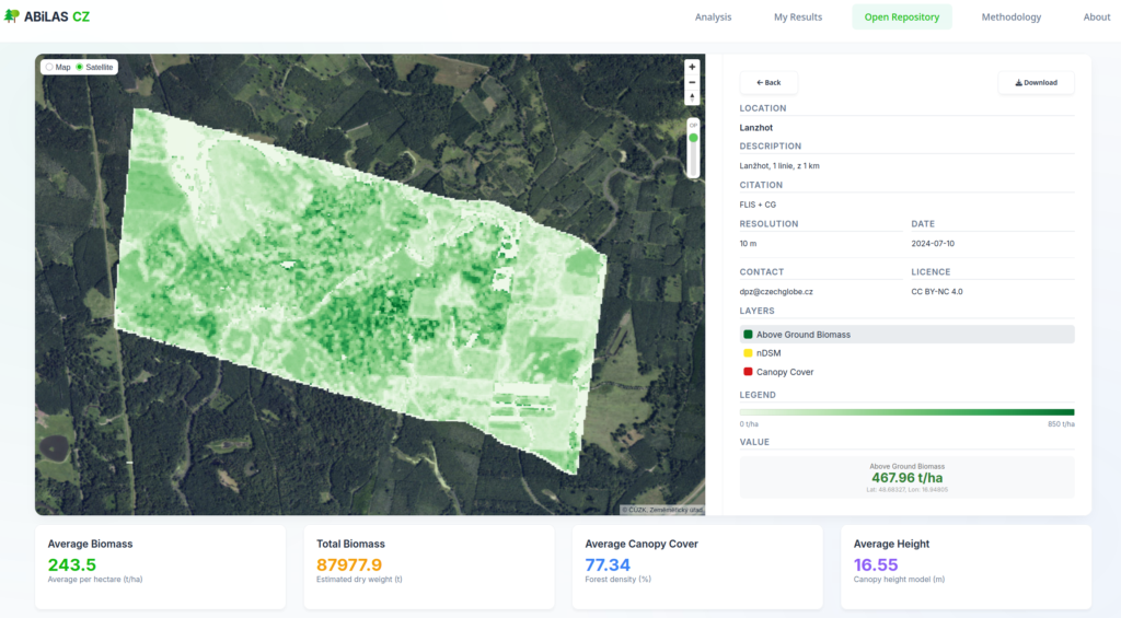
Datově-analytická platforma EnviLab sloužící k efektivnímu zpracování velkých objemů heterogenních dat v oblasti životního prostředí nově zahrnuje modul ABiLAS. ABiLAS je nástroj, který na základě prostorové analýzy leteckých laserových dat umožňuje odhadnout nadzemní biomasu lesa. To vše jen na pár kliknutí. Dalším přínosem je generování map průměrné výšky porostu a hustoty lesa.
Více 
Jakých teplot mohou během horkých letních dnů dosahovat různé povrchy ve městech? Jak velký je rozdíl mezi teplotou tmavé a světlé dlažby? O kolik stupňů dokáže městská zeleň ochladit své okolí? A jak vlastně okolní prostředí ovlivňuje tepelnou pohodu člověka?
To jsou otázky, které si v období letních vln veder klademe stále častěji. Díky terénním a leteckým měřením teplotních charakteristik městských povrchů dnes dokážeme na mnohé z nich nabídnout konkrétní a daty podložené odpovědi.
V rámci aktivit Oddělení dálkového průzkumu Země postupně vzniká série nových infografik věnovaných fenoménu městského tepelného ostrova a teplotnímu prostředí měst. Infografiky srozumitelnou formou představují výsledky měření i nejzajímavější poznatky o fungování městského klimatu. Zaměřují se především na město Brno, které je nám geograficky, profesně a srdcem nejbližší, avšak závěry lze zobecnit i pro další česká města.
Nové informační materiály pomohou lépe pochopit, jak různé typy povrchů, vegetace či zástavby ovlivňují tepelné podmínky ve městech a jaká opatření mohou přispět ke zmírnění dopadů rostoucích teplot na kvalitu života obyvatel.
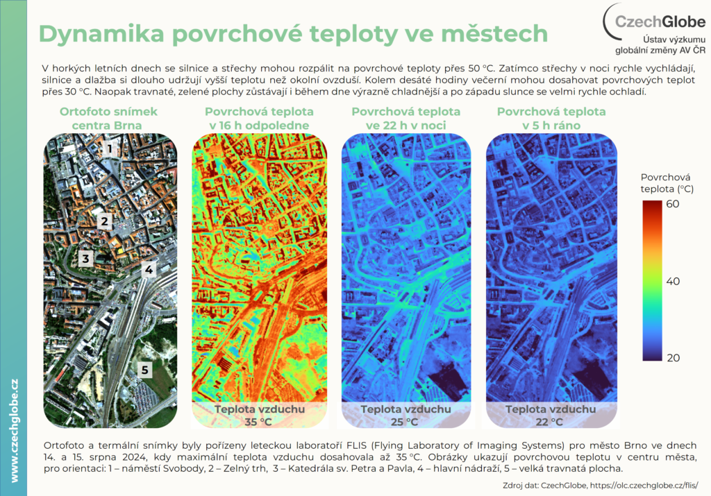
Během uplynulé vlny veder, 28. června, zažilo Česko svůj nejteplejší den. Tyto parné dny znamenají zvýšenou zátěž pro lidský organismus. Právě proto v tento den vyrazili vědci z Oddělení dálkového průzkumu Země do ulic centra Brna s přístrojem vlastní výroby pojmenovaným „Uličník“, aby změřili aktuální teplotu a vlhkost vzduchu, oslunění a sálání z okolních povrchů, což jsou veličiny potřebné k výpočtu pocitové teploty, nebo-li fyziologicky ekvivalentní teploty (PET), která popisuje tepelnou pohodu člověka. Teplota vzduchu, kterou nám měří teploměry za oknem, totiž nevypovídá přesně o tom, jak horko skutečně vnímáme.
Více Events / Projects / Research


Věda stojí za Ukrajinou
